
    |
|
| Organizer | SUZA / TANZANIA FLYING LAB/COLA & IRD / IFREMER / GISCAN |
| Venue | ZANZIBAR – State University of Zanzibar (Tungu Campus): |
| Dates | From SATURDAY 25/08 8 :00 AM to SUNDAY 26/08 02 :00 PM |
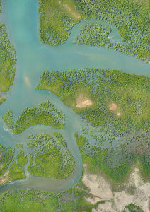
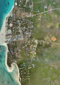
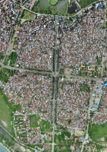
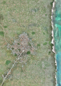
| Description | From 2016 to 2018, Zanzibar has been mapped entirely using Drones to produce a open aerial map of the entire island … this is the Zanzibar Mapping Initiative (say ZMI) …. the largest area ever surveyed using low-cost drones …
The project itself has served as a catalyst for the geospatial community in Zanzibar, which has effectively been deemed an ‘Island of Innovation’. The State University of Zanzibar, is a very active partner of one of the region’s most active Drone Labs, called the Tanzania Flying Lab. During this workshop you will get to know the team who made that project possible … and maybe launch a fixed – wing drone for the first time of your life …
To make this workshop even more exciting, ZMI team has invited some Marine Geo Geek from IFREMER and GISCAN to tell us more about underwater data collection … this is the Marine part of the workshop : IFREMER/GISCAN works on establishing marine data sets suitable for habitat mapping and species observations. Their specialty is to combine underwater images from drones or basic camera solutions with positional information from the surface. The main activities are centered around Indian Ocean Islands. Together the two projects represent emerging technologies where both commercial and open source software plays a key role. During this 2 days workshop you will get to know the theory and the practical aspects of aerial and underwater data acquisition and processing. Local experts will be available for further discussion. Day one:
Day two :
|
| Workshop details | Aerial Drones
Through a set of presentations we will outline how ZMI project was established, how it was funded and also what it took to get partners and multiple individual contributors to collaborate. A technical walkthrough of the project is also central to the presentations. Focus will be on how to achieve an open source workflow to produce an open data set. Legal aspects are a part of this presentation. In the practical session we will show how the work is done and touch into practical challenges on operating drones and establishing a viable data management structure. Participants will be given a basic introduction to handling drones and getting them into the air. Managing the workflow and capturing the raw imagery is important. Likewise is the data management after data collection. Processed data will need a proper metadata and storage facilities. We will present an ideal data flow from capture to data release. Participants will learn:
Marine We will give an overview of methods used to survey under water areas. We will exemplify this with recent projects done in Mauritius . The use of underwater cameras in combination with GPS loggers is described and relevant open source software to georeferenced the images is also described. We will bring sample data so that users can train on quality data. In the practical session we will equip a boat with the described setup. This will take us to the seaside where different platforms, fishing boats, canoes, surboards and similar, can be set up as scientific data collection platforms. Rounding off we will show how photos and metadata can be stored in a postgis database and later displayed using geonetwork. Should we have time we will also look at how images can be prepared for analysis using machine learning procedures. |
| Practical details | Saturday 25/08:
Sunday 26/08
MaruMaru Hotel : |
| What to bring for the workshop ? | Laptop. Hat. Sun Cream. Swimming Costume.
To collect underwater pictures: personal smartphones, waterproof action cameras, kite surf, snorkelling gears for those who can/want to. |
| Nb of participants | The more we are … the better it is … but make sure you book early to make sure you can be part of it. We will close the workshop at 30 participants to make sure every participant can enjoy !! |
| Cost for the 2 days workshop | |
| WORKSHOP COST – 70 USD
Includes : transport during the day, food and drinks during the day. Participants have to take care of their own accommodation (Many hotels In Zanzibar at all prices, book soon, august is peak season in Zanzibar). For those interested, special arrangements have been made with the MaruMaru hotel : 80 usd/night single room ; 120 usd double room. There is a roof top swimming pool … and it is in the vibrant heart of StoneTown. (just mention FOSSFOURG when you book !!). If you want to find a hotel by yourself … there are hundreds of hotels available on the island … just chose the one you want (not too far from StoneTown).
|
|
| How to get to Zanzibar ? | You can get a direct flight from all over the world and land in Dar-Es-Salaam or Zanzibar. Zanzibar and Dar-Es-Salaam are very close and you can commute between the 2 destinations very easily:
By fast ferry (5 ferries/day ; Duration : 2 hours ; 7h – 9h30 – 12h30 – 14h – 15h30). Only one ferry company. Visit : http://www.azammarine.com/schedule/ Ferry Terminal :
By plane, more than 20 planes/day in both direction with several companies: visit the websites of COASTAL AVIATION, AURIC AIR, ZAN AIR, TROPICAL AIR. Airport :
|